October 2021 Weather Summary for Belize
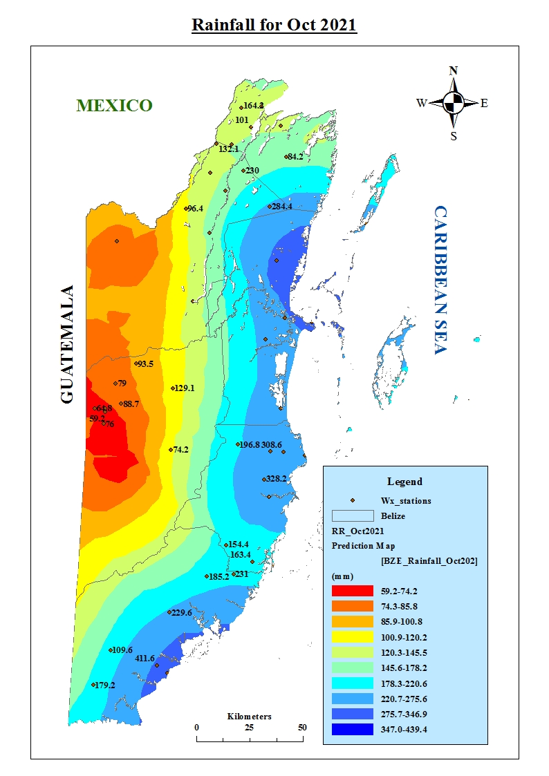
October is one of the months were tropical storms and hurricanes peaks, but this month was rather quiet with not much tropical activity. Rainfall can also be attributed to on average 3 Upper-Level Troughs, 5 Tropical waves and 1 Surface Troughs. During the month, four tropical waves crossed the country and several surface troughs over the area near the northwest Caribbean and the Yucatan. Overall, rainfall was below average over most areas, except for parts of central coastal Belize.
The first week saw relatively moist conditions over most areas in both the low and upper levels on most days due to a moist and light east to north-easterly airflow from surface troughs lingering over the area and the approach and passage of a tropical wave on October 7. At the upper levels, ridging was the dominant feature which supported a north-easterly wind component and neutral to weakly convergent pattern for most of the week. On October 6 and 7, the approaching tropical wave led to upper-level conditions becoming weakly divergent with the high-pressure ridge over the western Caribbean supporting a more south-easterly flow. A few showers and affected most areas during the beginning of the week due to lingering moisture from the passage over a tropical wave at the end of the previous month. A temporary break was observed at the middle of the week, but rainfall activity increased on October 6 and 7 due to the tropical wave where some showers, periods of rain and thunderstorms affected most areas along with early morning fog on October 7.
Week 2 continued moist through October 8 and 9 with a slack pressure gradient and a light easterly flow over Belize and the northwest Caribbean. Ridging continues to dominate at the upper level and a north-westerly flow prevailed with a weakly divergent pattern. This supported showers and thunderstorms across the country with most activity occurring during the night, then affecting mostly northern and southern areas during the daytime. Moisture levels began to decrease over the area leading the low and upper levels to become dry. Showery activity decreased over most areas October 10 to 14 supporting only isolated showers or thunderstorms over the Maya mountains and southern Belize. A weak tropical wave crossed the country on October 12 and 15 but not much activity was associated with these waves. In the upper levels, troughing was observed at the levels over Belize because of an upper level low over the Bahamas and a north-westerly upper-level wind component was observed.
The upper-level trough extended to the surface supporting a light east to north-easterly flow over the area and only a few showers over the mountains and southern Belize on October 15 in week 3. Moisture levels were relatively low, but a gradual increase was observed at first in the low levels then extended to the upper levels by October 18. Most of the showery activity continued to affect the mountainous areas and southern Belize while conditions continue neutral at the upper levels over the area. An increase in low and upper-level moisture was observed on October 18 through to October 21 as a cold front approached the area and became stationary over the Bay of Campeche before lifting north of the area. This led to an increase in cloudiness and instability further supported by a weakly divergent upper-level pattern due to a south-westerly upper-level flow from a ridge over the western Caribbean. Thus, showers and thunderstorms developed and continued to affect southern Belize on October 19 before increase and affecting most areas. On October 20, a diurnal pattern was observed in the rainfall activity with showers and thunderstorms affecting southern and some inland areas during the night-time and affected northern, coastal, and offshore areas during the day. This continued into October 21 affecting mostly northern areas and dissipated by with afternoon with radar imagery showing rainfall activity across the country by nightfall.
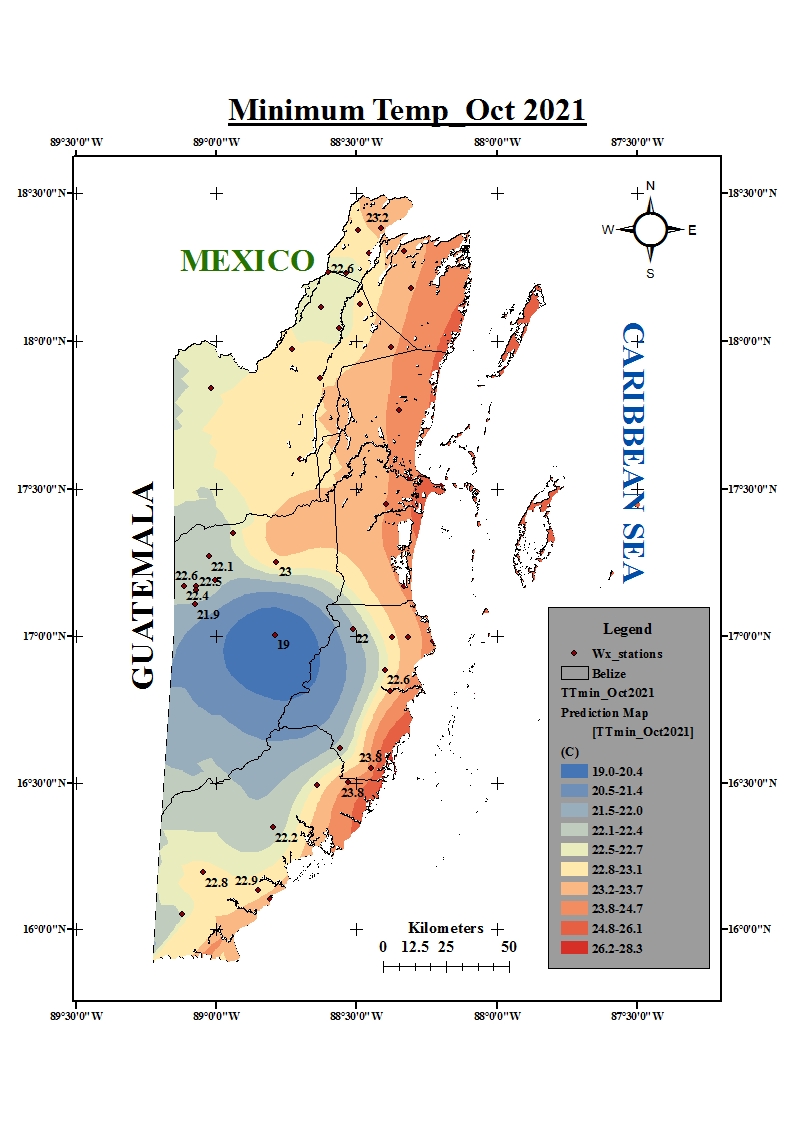
Moist conditions prevailed going into the last week of the month with light easterly surface flow and a south-westerly component at the upper levels influenced by an upper-level jet north of the area. A few early morning showers and thunderstorms affected mostly northern, central, and offshore areas and decreased in the afternoon on October 22. October 23 and 24 were relatively dry, however, a few showers and isolated thunderstorms were observed primarily over southern and inland areas. Another increase in moisture and instability occurred on October 25 as a cold front moved into the northern Gulf of Mexico. October 26 and 28 saw ridging as the dominant feature over the area and supported a dry and warm south-easterly flow and only a few showers mostly over the mountain and southern areas. The front moved over the north-western Yucatan on October 28 extending from northern Florida. This front was the first front of the season to cross Belize and did so in October 29, however, not much rainfall activity was associated with it as only a few showers were observed from pre-frontal activity over central, southern, and offshore areas overnight on the 28th. The front became stationary on October 30 over north- eastern Nicaragua and supported a cool north-westerly surface flow. The high pressure behind the front supported fair and dry conditions behind the front. The lowest temperature was observed at the Central Farm station with a value of 15.6 oC in the Cayo District on October 31.
Click on the link below to view the rainfall map for October 2021:
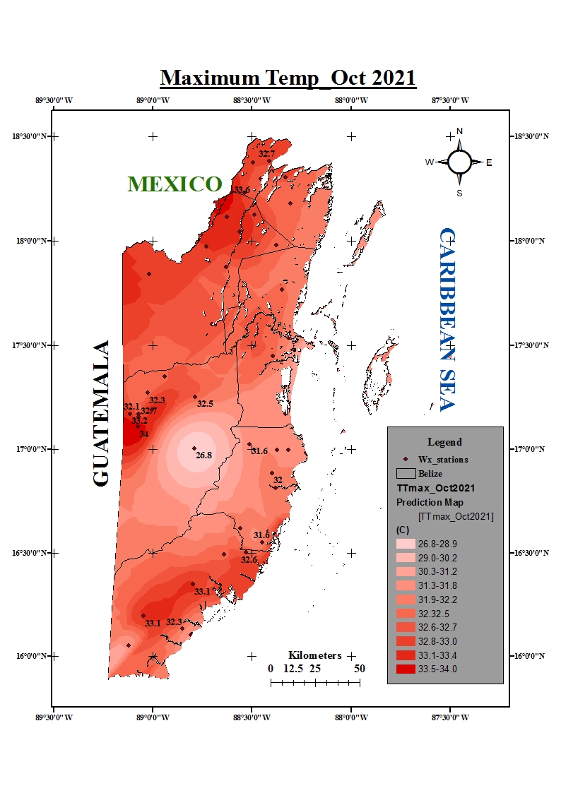
Click on the links below to view the temperature(max. and min.)maps for October 2021: